
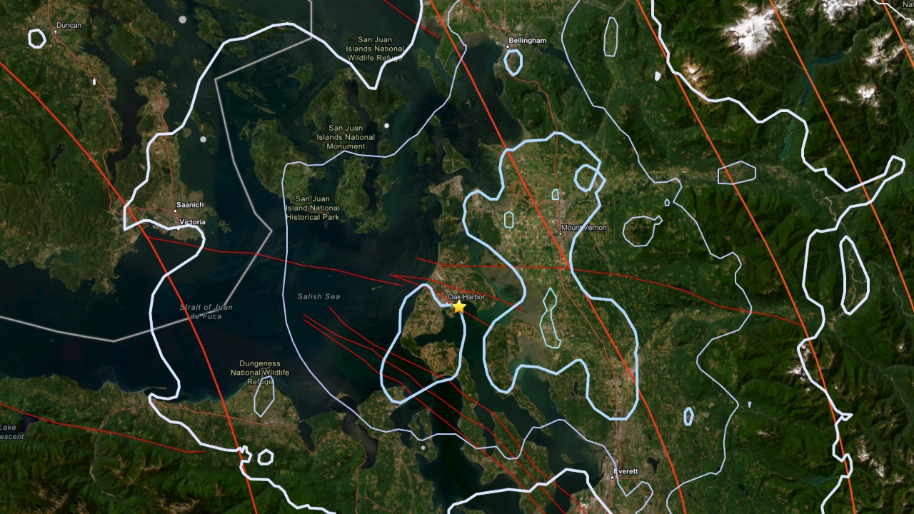
Epicenter of the magnitude 3.8 Oak Harbor earthquake, marked by the star, shown with nearby fault lines and Cascadia plate boundary indicators. (Map Source: USGS)
OAK HARBOR, Wash. — A magnitude 3.8 earthquake shook parts of western Washington early Thursday morning after a smaller tremor struck less than a minute earlier. Several additional earthquakes followed over the next few hours, according to the U.S. Geological Survey.
The strongest quake occurred at 6:35:47 a.m. PDT, about 2 kilometers (1.2 miles) east-southeast of Oak Harbor, at a depth of 25.3 kilometers (15.7 miles).
The shaking reached communities across Whidbey Island, the North Puget Sound and surrounding areas.
Earthquake Was Part of a Short Sequence
USGS data show Thursday’s magnitude 3.8 earthquake was not an isolated event.
The sequence began with a magnitude 2.4 earthquake at 6:34:54 a.m., just 57 seconds before the mainshock.
Following the magnitude 3.8 event, seismologists recorded:
- Magnitude 2.3 at 6:48:56 a.m.
- Magnitude 1.4 at 7:07:18 a.m.
- Magnitude 2.0 at 10:50:54 a.m.
All five earthquakes occurred within roughly 3 kilometers of Oak Harbor, indicating a localized seismic sequence beneath Whidbey Island.
While the USGS has not formally classified the sequence, the pattern is consistent with a foreshock, mainshock and aftershock sequence, a common occurrence following moderate earthquakes.
More Than 1,600 People Reported Feeling It
As of Thursday morning, the USGS “Did You Feel It?” system had received more than 1,600 public reports from people who felt the earthquake.
The agency assigned the event a Modified Mercalli Intensity (MMI) IV, which indicates light shaking. Many people indoors likely felt the quake, and some windows or dishes may have rattled. Damage is generally not expected at that intensity.
Communities closest to the epicenter include:
- Oak Harbor: 1.6 miles
- Camano Island: 8.7 miles
- Anacortes: 15.6 miles
- Mount Vernon: 15.7 miles
- Victoria, British Columbia: 35.6 miles
No injuries or damage were immediately reported.
Why Earthquakes Are Common in Western Washington
Washington lies above the Cascadia Subduction Zone, where the Juan de Fuca Plate slowly dives beneath the North American Plate. That movement produces thousands of earthquakes across the Pacific Northwest each year.
The Oak Harbor earthquake occurred about 25 kilometers below the surface, near the transition between shallow crustal earthquakes and deeper earthquakes within the descending Juan de Fuca Plate.
The region also contains several known fault systems, including the South Whidbey Island Fault, Devil’s Mountain Fault, Seattle Fault Zone and Tacoma Fault.
No Tsunami Threat
A magnitude 3.8 earthquake at this depth is not capable of generating a tsunami, and no tsunami advisories were issued.
Scientists will continue monitoring the area for additional activity, although aftershocks following earthquakes of this size typically diminish over time.