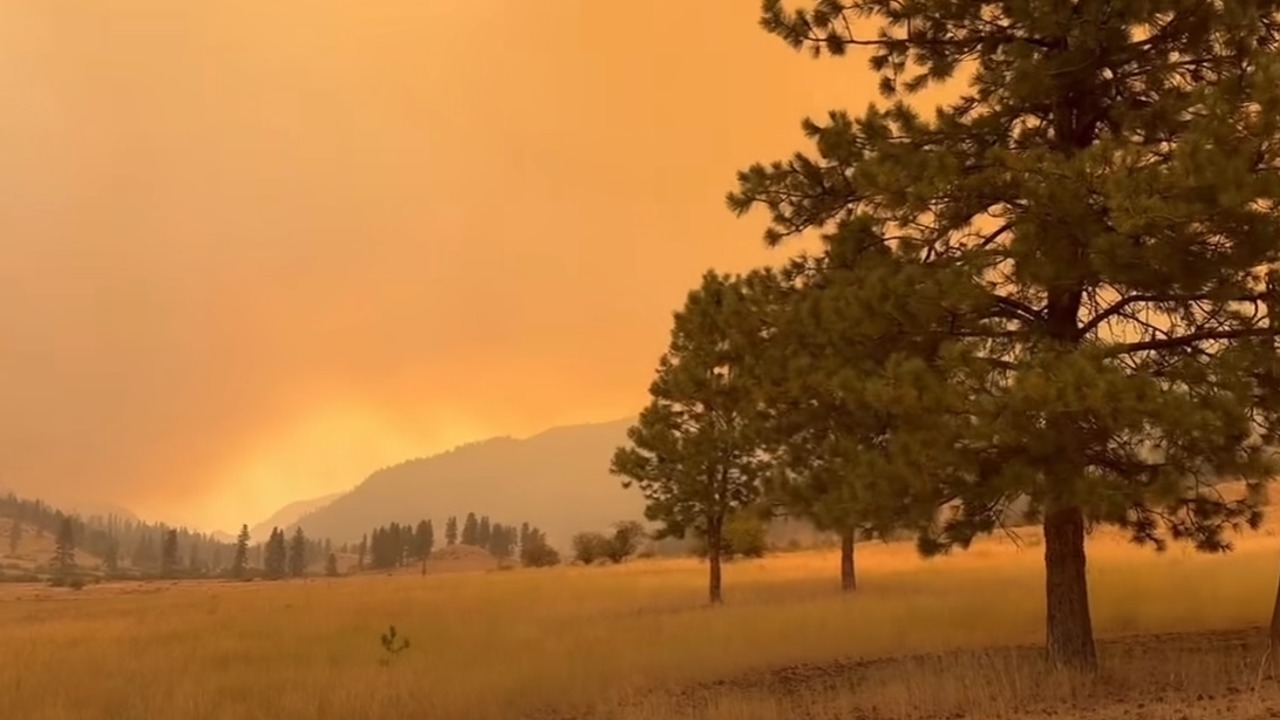
Smoke from the Sinlahekin Fire fills the sky near Loomis on July 30. The lightning-caused wildfire has burned more than 73,000 acres in Okanogan County. (Photo: Spokane County Fire District 8 Firefighters Local 3711)
SPOKANE, Wash. — A fast-moving wildfire destroyed homes across northwest Spokane on Saturday, turning an already severe Washington fire season into a devastating urban disaster.
The Old Trails Fire raced through Riverside State Park, crossed the Spokane River and entered residential neighborhoods. Flames consumed homes as thousands of people fled under Level 3 evacuation orders.
By Sunday morning, officials confirmed that fires around Spokane had destroyed at least 640 structures, up from Saturday night’s preliminary estimate of about 600, and forced evacuations affecting approximately 5,000 homes. No deaths or injuries had been confirmed, though Spokane County Fire District 3 Chief Cody Rohrbach said the fire’s speed and the number of structures lost raised the potential for loss of life as crews continued working to confirm no one remained missing.
The Old Trails Fire had grown to roughly 3,500 acres with no containment. Meanwhile, the Fairview and Autumn Lane fires also expanded near Spokane. Together, the three fires, now managed collectively as the Spokane Area Fires, had burned roughly 7,500 acres and left entire neighborhoods facing catastrophic losses.
State officials said extreme heat, dry vegetation and wind gusts reaching 45 mph contributed to the explosive fire growth.
The City of Spokane warned people to stay out of evacuation areas as firefighters and residents tried to escape the advancing flames.
“Please do not drive into the Old Trails Fire evacuation zone. For those in the evacuation zone, please head eastbound. Use side streets.”
City of Spokane
Old Trails Fire Reaches Spokane Neighborhoods
The Old Trails Fire started near Airway Heights at approximately 11:56 a.m. Saturday. An initial state mobilization notice estimated the fire at just 100 acres.
However, strong winds pushed it rapidly north and east. The fire crossed the Spokane River and entered neighborhoods near Indian Trail and Five Mile Prairie.
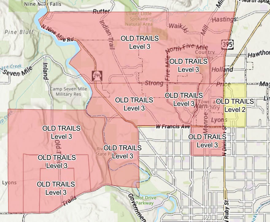
Level 3 “Go Now” evacuation zones covered large portions of northwest Spokane. Other nearby neighborhoods received Level 2 notices, directing residents to prepare to leave.
Emergency officials urged people to use the Spokane Regional Emergency Communications evacuation map for the latest evacuation boundaries.
The fire also forced evacuations at several major facilities, including the Mann-Grandstaff VA Medical Center. Officials confirmed that structures had burned, and by Sunday morning the campus remained closed, with patients transferred to local hospitals or relocated to shelters under VA staff supervision.
Three Major Fires Burn Around Spokane
Two other fires erupted in Spokane County within hours of the Old Trails Fire.
The Fairview Fire started near Mead at approximately 2:07 p.m. Saturday. The initial state notice estimated it at 300 acres. By Sunday morning, the fire had grown to nearly 1,000 acres.
The Autumn Lane Fire started near Nine Mile Falls and Suncrest at approximately 3:22 p.m. Officials initially estimated it at 200 acres. The fire later grew to approximately 3,300 acres as flames threatened communities in Spokane and Stevens counties.
Washington authorized state mobilization for all three fires. The initial orders sent five strike teams to each incident.
California also sent an incident management team to assist with what officials have named the Spokane Area Fires, also referred to as the Spokane Complex. California Interagency Incident Management Team 7 took command of the response, and a shelter for evacuees opened at the Spokane Convention Center.
Red Sky Fire Burns Near Union Gap
Washington also mobilized resources Saturday for the Red Sky Fire near Union Gap in Yakima County.
The fire started at approximately 5:30 p.m. and grew to an estimated 600 acres by the time of the state notice. It burned through brush, grass and timber while threatening homes, infrastructure and cultural sites.
Officials issued Level 2 and Level 3 evacuation notices. The state ordered two strike teams to support local firefighters.
Investigators had not determined what caused the Old Trails, Fairview, Autumn Lane or Red Sky fires.
Sinlahekin Fire Explodes Across Okanogan County
Farther north, the lightning-caused Sinlahekin Fire continued its explosive growth in rural Okanogan County.
The fire had burned approximately 73,794 acres and remained at zero containment. It started July 26 about 12 miles west of Tonasket.
Driven by strong winds, the fire expanded by more than 41,000 acres during a single 24-hour period over the weekend. Gusts reached as high as 50 mph during the Red Flag Warning.
The fire threatened homes and critical communications equipment on Aeneas Mountain.
CAL FIRE Incident Management Team 4 deployed from California through the Northwest Compact Agreement, marking the first time a CAL FIRE incident management team has been mobilized to Washington. The team joined hundreds of firefighters already working on the incident.
Two Wildfires Remain Active in Whatcom County
Although the destruction in Spokane dominated the statewide emergency, two wildfires continued burning in remote eastern Whatcom County near Ross Lake.
The Border 2 Fire had burned more than 3,400 acres east of Ross Lake. Wind recently pushed the fire within a quarter-mile of the remote Hozomeen campground in North Cascades National Park.
Officials had not reported injuries or structural damage from the Border 2 Fire.
The National Park Service closed the Hozomeen area and Ross Lake north of Silver Creek Camp. It also closed several trails, campgrounds, boat-in camps and docks.
West of Ross Lake, the Luna Fire had grown to approximately 335 to 400 acres. Hot, dry and windy weather increased fire activity, including single-tree torching and uphill runs.
Closures connected to the Luna Fire include portions of the Big Beaver Trail, several backcountry camps and the Luna and Prophet cross-country zones.
Burnout Road Fire Contained
Local crews contained the Burnout Road Fire after it burned approximately 63 acres near Northwood Road in Whatcom County.
The vegetation fire did not remain part of the county’s active wildfire count Sunday. However, its rapid growth demonstrated how easily dry grass and brush can ignite under current conditions.
Stage 2 Burn Ban Covers Whatcom County
The Whatcom County Fire Marshal has enacted a Stage 2 burn ban across the county. The ban aligns with a statewide burn ban Gov. Bob Ferguson ordered Saturday amid a record-setting drought, in effect through Sept. 30.
The ban prohibits all open burning, including recreational fires and wood-burning fire pits. People may use liquid-fueled or propane stoves when they follow safety requirements.
The National Park Service has also prohibited campfires and the use of wood, charcoal briquettes or similar fuels throughout the North Cascades National Park Service Complex.
Gas and propane stoves, grills and lanterns remain permitted when used safely.
Smoke Could Return to Western Washington
Changing winds could carry wildfire smoke into Whatcom County and other parts of Western Washington.
Smoke may come from the Border 2 and Luna fires, larger fires east of the Cascades or the Brunswick Creek Complex in British Columbia.
People with asthma, heart or lung disease, older adults, children and pregnant people face a higher risk from wildfire smoke. Residents can track current conditions at AirNow’s Fire and Smoke Map and develop a personal response plan through My Smoke Plan.
Washington officials urged residents statewide to monitor emergency alerts and prepare to evacuate if conditions change.
Frequently Asked Questions
About the Author