

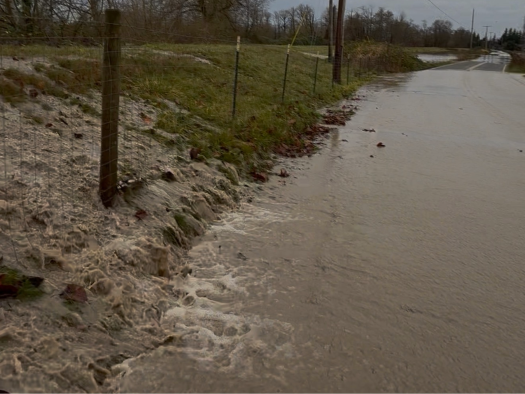
A levee along the Nooksack River reveals the river has breached its banks spilling into Lynden farmland. (PNW Daily staff)
DEMING, Wash. — Nooksack River dredging has returned to the center of the flood debate in Whatcom County as renewed high water again impacts communities along the river corridor.
The discussion intensified after claims circulated on social media and during a local weekend radio program in Bellingham suggesting the river was once dredged for flood control. Whatcom County records show that did not occur.
County documents indicate that historic gravel removal along the Nooksack served commercial purposes, not flood mitigation. Flooding continued during those mining operations, and officials concluded the practice did not reduce flood risk.
County Records Contradict Dredging Claims
According to Whatcom County records, commercial gravel scraping was never implemented as a flood control strategy.
Mining companies removed gravel for construction and industrial use. The activity did not prevent flood events, nor did it lower long-term water levels.
County staff have repeatedly stated that dredging did not provide meaningful protection during major floods.
Despite that history, some posts and on-air statements have suggested gravel removal once kept the river in check. Public records do not support that claim.
Why Sediment Keeps Returning
The Nooksack River originates on Mount Baker and Mount Shuksan.
According to the U.S. Geological Survey, those headwaters consist largely of unconsolidated glacial and volcanic material. That material erodes easily during heavy rain and snowmelt.
USGS research shows the river continuously transports large volumes of sediment downstream. When sediment accumulates faster than it can move out of the system, the riverbed rises and flood risk increases.
Removing gravel from one location does not stop new material from arriving.
Past Modifications Increased Flood Energy
NOAA Fisheries reports that historic removal of large woody debris simplified the river’s natural structure.
That change reduced the river’s ability to slow water and trap sediment. It also increased flood energy downstream.
Modern restoration projects now use engineered log jams to restore some of those lost functions.
NOAA says those structures also support salmon and steelhead habitat. The agency attributes population declines to multiple factors, including altered streamflows, warmer water, habitat loss, and sediment instability.
NOAA does not list dredging as a recovery strategy. The agency warns that unmanaged sediment removal can damage spawning areas.
Glacier Loss Adds More Sediment
USGS monitoring shows glaciers on Mount Baker and Mount Shuksan have retreated significantly.
That retreat increases sediment delivery and alters runoff timing.
While dredging remains technically possible, federal agencies note that increased sediment supply limits how long gravel removal remains effective.
Material removed from the riverbed often returns within a few seasons.
The Role of Former Sumas Lake
The former Sumas Lake once provided natural flood storage.
After the lake was drained for agriculture, floodwaters became confined by dikes, levees, and pumps. During extreme events, those systems can become overwhelmed.
When that happens, water returns to its historic basin.
That pattern has repeated during major floods for decades.
What State and Federal Agencies Recommend
The Washington Department of Ecology says long-term flood risk reduction requires multiple strategies working together.
Those include floodplain reconnection, levee setbacks, engineered wood placement, and land-use planning in high-risk areas.
According to NOAA, USGS, and state flood managers, the Nooksack River responds to geology, climate patterns, and decades of modification.
They say Nooksack River dredging may offer short-term benefits in limited locations but does not serve as a standalone solution.
Cross-Border Challenges Complicate Solutions
The Nooksack watershed extends into Canada.
During major flood events, water flows north into the former Sumas Lake basin. That movement follows natural topography, not political boundaries.
Canadian officials have pressed for solutions that would redirect water south. Such projects would require large-scale land conversion near Everson.
That level of intervention would displace residents and significantly alter ecosystems.
No agency has formally proposed a project of that scale.
A Model From Mount Vernon
Some communities have pursued structural flood protection.
Mount Vernon completed its Downtown Flood Protection Project in phases by 2019. The system includes floodwalls and earthen levees.
The project cost more than $31 million.
It earned FEMA certification and removed downtown from designated flood zones, reducing insurance costs and protecting critical infrastructure.
The system does not rely on dredging.
The problem is not on Canada’s side. We can handle the water we get here. It’s when the Nooksack goes over we get flooded here. It’a high time the USA takes care of their own water problem!