
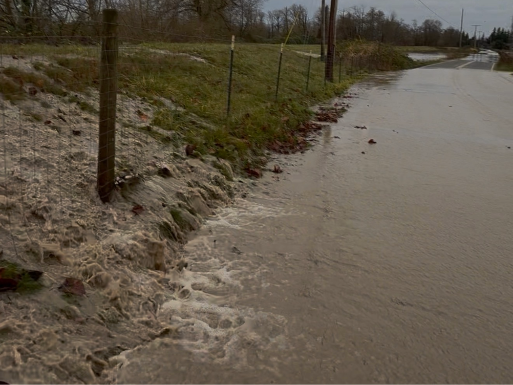
A levee along the Nooksack River reveals the river has breached its banks spilling into Lynden farmland. (PNW Daily staff)
FERNDALE, Wash. — Another atmospheric river is moving into Northwest Washington, bringing heavy rain, strong winds and renewed concerns about flooding in communities still recovering from December’s historic disaster. But current Skagit and Nooksack river forecasts from the National Weather Service show projected crests far below the record levels reached during last month’s flood.
Forecasters say rivers will rise through Tuesday. Current model guidance does not show a repeat of the catastrophic flooding that forced evacuations and inundated parts of Skagit and Whatcom counties in December.
Flood Threat Outlook Issued for Western Washington
The National Weather Service has issued a hydrologic outlook warning of a continued threat of river flooding through Tuesday for rivers flowing out of the Olympics and North Cascades.
Forecasters said moderate to heavy rain will continue. Some areas have already received 2 to 4 inches. Another 1 to 3 inches is expected, with the highest totals in the Cascades of Whatcom and Skagit counties.
Snow levels will remain between 7,000 and 8,000 feet. That will increase runoff into rivers.
Rivers in the outlook area will continue rising and crest later Monday into Tuesday, according to the National Weather Service.
Skagit and Nooksack River Forecasts Compared to December Flood Crests
During the December 2025 flood, the Skagit River reached historic levels.
Near Concrete, the Skagit crested at about 41.1 feet on Dec. 11. At Mount Vernon, the river peaked near 37.73 feet on Dec. 12.
Current Skagit River forecasts show much lower crests.
At Mount Vernon, models project a peak of about 28.9 feet. That puts the projected crest about 8.8 feet lower than the December peak.
Upstream near Concrete, the Skagit is forecast to crest near 26 feet. That is roughly 15 feet lower than December’s high-water mark.
The Nooksack River also reached record levels in December.
At North Cedarville, the river crested at 150.49 feet early on Dec. 11. That surpassed previous records, including those from the 2021 floods.
Downstream, floodwaters overtopped levees and flooded Everson, Nooksack and Sumas. In Ferndale, the river crested near 22.42 feet. That level fell just short of the major flood stage of 23 feet.
Current Nooksack River forecasts show lower peaks.
At North Cedarville, the river is forecast to crest near 143.27 feet. That is about 7.2 feet below the December record. On the North Fork near Glacier, the river is expected to peak near 6.49 feet. That remains well below flood thresholds.
Gale Warning Issued for Inland Waters
The National Weather Service has issued a Gale Warning for parts of Western Washington’s inland waters. The affected areas include the east entrance to the Strait of Juan de Fuca, the San Juan Islands and Admiralty Inlet.
Forecasters said southeast winds of 25 to 35 knots will persist through early Monday. Gusts could reach 40 knots. A Small Craft Advisory will follow through early afternoon. Winds during that period will range from 20 to 30 knots.
The agency warned that strong winds will create hazardous seas. Conditions could capsize or damage vessels and reduce visibility.
The National Weather Service urged inexperienced mariners to seek safe harbor.
Why This Storm Still Matters
This system arrives after weeks of repeated storms. Those storms saturated soils and damaged riverbanks. They also caused widespread flooding across the region.
When the ground stays saturated, more rain runs directly into rivers. That causes faster rises, even when totals stay lower than in past storms.
That does not guarantee major flooding.
How to Read River Forecasts
Many residents rely on social media for flood information. The most accurate data comes directly from the National Weather Service.
River forecast graphs show two key lines:
• Observed levels: what the river is doing now
• Forecast levels: where models expect it to crest
Flood categories vary by location. They include:
• Action Stage
• Minor Flooding
• Moderate Flooding
• Major Flooding
A river can rise several feet without entering flood stage.
Officials Urge Awareness, Not Alarm
Emergency managers urge residents near rivers to stay alert. Water levels can change quickly, especially overnight.
They recommend:
• Monitoring official NOAA forecasts
• Avoiding flooded roads
• Watching for bank erosion
• Following local advisories
This storm will bring heavy rain and strong winds. Still, current Skagit and Nooksack river forecasts show crests well below the historic levels reached in December.
River Crest Comparison: December 2025 Flood vs. Current Forecast
| River & Gauge Location | December 2025 Crest | Current Forecast Crest | Difference | Flood Stage |
|---|---|---|---|---|
| Skagit River near Concrete | ~41.1 ft (Dec. 11) | ~26.0 ft | ~15.1 ft lower | 28.0 ft |
| Skagit River at Mount Vernon | ~37.73 ft (Dec. 12) | ~28.9 ft | ~8.8 ft lower | 28.0 ft |
| Nooksack River at North Cedarville | ~150.49 ft (Dec. 11) | ~143.27 ft | ~7.2 ft lower | ~146.5 ft |
| North Fork Nooksack near Glacier | ~9.7 ft (Dec. 11) | ~6.49 ft | ~3.2 ft lower | ~10.0 ft |
Table: Comparison of December 2025 flood crests and current National Weather Service river forecasts for Skagit and Nooksack River gauges in Northwest Washington.


1 thought on “Skagit and Nooksack River Forecasts Show Crests Far Below December Flood Levels”